


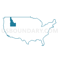
Bonner, Latah, Shoshone, Boundary, Benewah & Kootenai (Southeast) Counties PUMA, Idaho
About
Outline
+Counties+PUMA%2c+Idaho_A280.png)
Summary
| Unique Area Identifier | 192770 |
| Name | Bonner, Latah, Shoshone, Boundary, Benewah & Kootenai (Southeast) Counties PUMA |
| State | Idaho |
| Area (square miles) | 8,398.24 |
| Land Area (square miles) | 8,150.09 |
| Water Area (square miles) | 248.16 |
| % of Land Area | 97.05 |
| % of Water Area | 2.95 |
| Latitude of the Internal Point | 47.71506250 |
| Longtitude of the Internal Point | -116.34718850 |
Maps
+Counties+PUMA in Idaho.png)
Graphs
Select a template below for downloading or customizing gragh for Bonner, Latah, Shoshone, Boundary, Benewah & Kootenai (Southeast) Counties PUMA, Idaho
+Counties+PUMA%2c+Idaho_T0.png)
+Counties+PUMA%2c+Idaho_T1.png)
+Counties+PUMA%2c+Idaho_T2.png)
+Counties+PUMA%2c+Idaho_T3.png)
+Counties+PUMA%2c+Idaho_T4.png)
+Counties+PUMA%2c+Idaho_T5.png)
+Counties+PUMA%2c+Idaho_T6.png)
+Counties+PUMA%2c+Idaho_T7.png)
+Counties+PUMA%2c+Idaho.png)
Neighbors
Neighoring Public Use Microdata Area (by Name) Neighboring Public Use Microdata Area on the Map
- Central Idaho--Lewiston City & Nez Perce Reservation PUMA, ID
- Kootenai County (Northwest)--Coeur d'Alene, Post Falls & Hayden Cities PUMA, ID
- Northwest Montana--Kalispell City PUMA, MT
- Spokane County (Outer)--Cheney City PUMA, WA
- Stevens, Okanogan, Pend Oreille & Ferry Counties PUMA, WA
- West Montana--Missoula City PUMA, MT
- Whitman, Asotin, Adams, Lincoln, Columbia & Garfield Counties PUMA, WA
Top 10 Neighboring County (by Population) Neighboring County on the Map
- Spokane County, WA (471,221)
- Kootenai County, ID (138,494)
- Whitman County, WA (44,776)
- Bonner County, ID (40,877)
- Nez Perce County, ID (39,265)
- Latah County, ID (37,244)
- Lincoln County, MT (19,687)
- Pend Oreille County, WA (13,001)
- Shoshone County, ID (12,765)
- Sanders County, MT (11,413)
Top 10 Neighboring County Subdivision (by Population) Neighboring County Subdivision on the Map
- Coeur d'Alene CCD, Kootenai County, ID (72,052)
- Lewiston CCD, Nez Perce County, ID (34,319)
- Pullman CCD, Whitman County, WA (31,900)
- Moscow CCD, Latah County, ID (26,914)
- Sandpoint CCD, Bonner County, ID (18,701)
- Spirit Lake-Athol CCD, Kootenai County, ID (14,973)
- Blanchard-Glengary CCD, Bonner County, ID (14,485)
- Newport CCD, Pend Oreille County, WA (10,902)
- Kellogg CCD, Shoshone County, ID (6,991)
- St. Maries CCD, Benewah County, ID (6,781)
Top 10 Neighboring Place (by Population) Neighboring Place on the Map
- Moscow city, ID (23,800)
- Sandpoint city, ID (7,365)
- Bonners Ferry city, ID (2,543)
- St. Maries city, ID (2,402)
- Newport city, WA (2,126)
- Kellogg city, ID (2,120)
- Spirit Lake city, ID (1,945)
- Priest River city, ID (1,751)
- Pinehurst city, ID (1,619)
- Osburn city, ID (1,555)
Top 10 Neighboring Elementary School District (by Population) Neighboring Elementary School District on the Map
- Thompson Falls Elementary School District, MT (3,556)
- Troy Elementary School District, MT (2,850)
- Noxon Elementary School District, MT (1,421)
- Trout Creek Elementary School District, MT (1,130)
- McCormick Elementary School District, MT (351)
Top 10 Neighboring Secondary School District (by Population) Neighboring Secondary School District on the Map
- Troy High School District, MT (3,583)
- Thompson Falls High School District, MT (3,556)
- Noxon High School District, MT (2,551)
Top 10 Neighboring Unified School District (by Population) Neighboring Unified School District on the Map
- Coeur d'Alene School District 271, ID (71,692)
- Pullman School District, WA (31,922)
- Lake Pend Oreille School District 84, ID (29,408)
- Moscow School District 281, ID (27,525)
- Lakeland Joint School District 272, ID (26,553)
- West Bonner County School District 83, ID (11,433)
- Boundary County School District 101, ID (10,972)
- Orofino Joint School District 171, ID (8,993)
- Kellogg Joint School District 391, ID (8,365)
- Newport School District, WA (8,083)
Top 10 Neighboring State Legislative District Lower Chamber (by Population) Neighboring State Legislative District Lower Chamber on the Map
- State House District 4, WA (141,254)
- State House District 9, WA (136,166)
- State House District 7, WA (130,475)
- State House District 5, ID (46,466)
- State House District 3, ID (45,166)
- State House District 4, ID (44,634)
- State House District 1, ID (40,210)
- State House District 7, ID (39,265)
- State House District 8, ID (38,711)
- State House District 6, ID (37,244)
Top 10 Neighboring State Legislative District Upper Chamber (by Population) Neighboring State Legislative District Upper Chamber on the Map
- State Senate District 4, WA (141,254)
- State Senate District 9, WA (136,166)
- State Senate District 7, WA (130,475)
- State Senate District 5, ID (46,466)
- State Senate District 3, ID (45,166)
- State Senate District 4, ID (44,634)
- State Senate District 1, ID (40,210)
- State Senate District 7, ID (39,265)
- State Senate District 8, ID (38,711)
- State Senate District 6, ID (37,244)
Top 10 Neighboring 111th Congressional District (by Population) Neighboring 111th Congressional District on the Map
- Congressional District (at Large), MT (989,415)
- Congressional District 1, ID (841,930)
- Congressional District 5, WA (723,609)
Top 10 Neighboring Census Tract (by Population) Neighboring Census Tract on the Map
- Census Tract 2, Kootenai County, ID (8,703)
- Census Tract 9502, Bonner County, ID (8,477)
- Census Tract 18, Kootenai County, ID (8,251)
- Census Tract 51, Latah County, ID (7,583)
- Census Tract 6, Whitman County, WA (7,383)
- Census Tract 9504, Bonner County, ID (6,857)
- Census Tract 53, Latah County, ID (6,461)
- Census Tract 52, Latah County, ID (6,435)
- Census Tract 54, Latah County, ID (6,435)
- Census Tract 1, Kootenai County, ID (6,270)
Top 10 Neighboring 5-Digit ZIP Code Tabulation Area (by Population) Neighboring 5-Digit ZIP Code Tabulation Area on the Map
- 99163, WA (31,404)
- 83843, ID (25,866)
- 83814, ID (23,371)
- 83835, ID (19,990)
- 83864, ID (17,076)
- 99156, WA (8,114)
- 83805, ID (7,437)
- 83861, ID (6,360)
- 83856, ID (6,340)
- 83801, ID (6,150)